top of page

42nd Committee on Space Research (COSPAR)

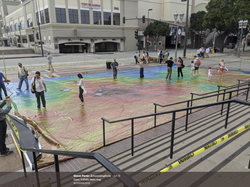
On July 18th, 2018 we displayed the map at the COSPAR Scientific Assembly in Pasadena, CA. Planetary scientists from around the world and members of the public were able to walk across the map and explore Mars for themselves prior to the COSPAR Public Lecture. Since we were slightly constrained on space, we were only able to unroll approximately 2/3 of the map, but everyone was still excited to walk along Valles Marineris and get a selfie standing on the summit of Olympus Mons!

cospar_03
cospar_02
cospar_01
cospar_04
cospar_05

ABOUT US >

The 2001 Mars Odyssey spacecraft and the Thermal Emission Imaging System (THEMIS) have been acquiring infrared images of Mars for more than 16 years. The best-quality images from the mission have been compiled into a global mosaic at 100 m/pixel resolution and printed on a walkable basketball-court-sized vinyl mat to spread awareness and excitement about Mars exploration!

Homepage Background Image: Full-disk image of Mars with the Tharis volcanoes in the west and Valles Marineris in the east from the Mars Orbiter Mission (MOM) Mars Color Camera (MCC). Image courtesy of the Indian Space Research Organization (ISRO), the Indian Space Science Data Center (ISSDC) and Emily Lakdawalla.

bottom of page